Programozó versenyekDEIK Regionális Programozó Csapatverseny, nyílt kategória, 2022. december 4.
2022. december 4. 10:00 –
2022. december 4. 15:15
|
sí

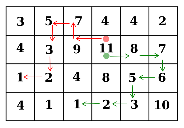
A fenti kép egy hegyvidéki terep domborzati térképe mátrix formában.
A számok az adott hely magasságát jelentik. Síelni akarunk és minél hosszabb jó
utat keresünk a terepen. Egy utat jó-nak nevezünk ha az egymás utáni
helyek vízszintes vagy függőleges irányban (diagonálisan nem!) szomszédosak benne és a magasság minden lépésben szigorúan csökken.
Az ábrán a 11-ből induló zöld nyíllal jelölt út a
(2,4),(2,5),(2,6),(3,6),(3,5),(4,5),(4,4),(4,3) helyek sorozata,
ahol az első számok a sor, a második számok az oszlop sorszámát jelentik.
Könnyen látható, hogy ez egy jó út, ahogyan az ábrán levő piros is az.
Az út hosszán az érintett helyek (darab)számát értjük,
az ábrán a zöld út 8,
a piros 7 hosszú.
Feladat: számoljuk ki a leghosszabb jó út L hosszát.
A bemenet specifikációja
R C
t11 ... t1C
t21 ... t2C
...
tR1 ... tRC
Az első sorban az 1 ≤ R,C ≤ 100 szóközzel elválasztott számok a térkép sorainak és oszlopainak számát jelölik. A következő R sor mindegyike C szóközzel elválasztott pozitív számot tartalmaz, melyek nem nagyobbak mint 106 .
A kimenet specifikációja
L
Egyetlen sor a leghosszabb jó út L hosszával.
1. példa bemenet
2 21 23 4
1. példa kimenet
3
2. példa bemenet
3 41 2 3 34 5 4 27 6 5 6
2. példa kimenet
7
3. példa bemenet
4 63 5 7 4 4 24 3 9 11 8 71 2 4 8 5 64 1 1 2 3 10
3. példa kimenet
8